 On the Flat Earth, The Sun Never Sets!
New Mexicans for Science and Reason
presents
On the Flat Earth, The Sun Never Sets!
by Dave Thomas

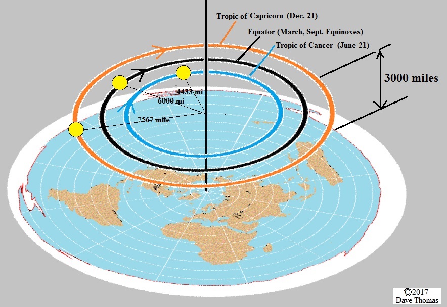
On this page, the paths of the sun in the Flat Earth model shown below are compared to the actual (a.k.a. "Round Earth/Globe Model/Heliocentric/Mainstream Science") solar paths. I am assuming that the Sun floats 3,000 miles above the "flat" earth, and makes a circular orbit each day. (If this is not the best Flat Earth model, PLEASE send me a citation for a better one!) On June 21st, the radius of that orbit is some 4433 miles, putting the sun directly over the Tropic of Cancer. On December 21st, the radius of the sun's orbit is some 7567 miles, putting the sun directly over the Tropic of Capricorn. On the Equinoxes (March 21 and Sept 21), the sun is directly above the Equator (with a radius of 6,000 miles). The Sun completes the circle once every day, going farther in December than in March or September, and going the shortest distance per day in June.
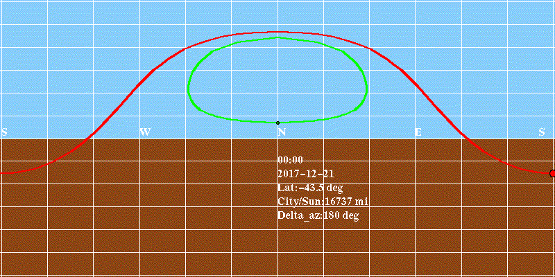
The image below shows the paths of real and FE suns in New Zealand on December 21st. This animation shows how the real sun (red) rises in the southeast, and sets in the southwest, all while the Flat Earth sun (green) stays entirely to the north, and never sets at all! (In fact, the lowest the Flat Earth Sun gets is 10 degrees above the horizon. That's about the same as the width of your fist, held out at arms length!) To disprove the Flat Earth model, someone in New Zealand could simply observe the sun shortly before sunset on the evening of December 21st. If it appears in the SOUTHWEST, as the globe model demands, then the Earth is Round. (In the Flat Earth model, the sun would "set" in the NORTHWEST!)
The sizes of both globe and flat-earth solar disks are exaggerated 10x for visibility; note that the Flat Earth sun changes size dramatically. Distances from the city that is the viewpoint (e.g. Christchurch) are indicated in miles, including the distance of the Flat Earth sun above the plane of the Earth (here, the flat earth sun is considered to be floating 3000 above the tropic of Capricorn). For this simulation, both real and FE suns are due north at noon. The grid is an Equirectangular Projection - it is simply straight elevation (15 deg. per grid box) and azimuth (30 deg. per box). Below the horizon is brown, and above it, blue. The central part of the projection is close to what you would see looking North or South; however, the grid encompasses the entire sphere, with azimuths from South to North to South again, and elevations from the Zenith to the Horizon to the Nadir. These animations were made with my own Python app, using the Python Imaging Library (PIL).
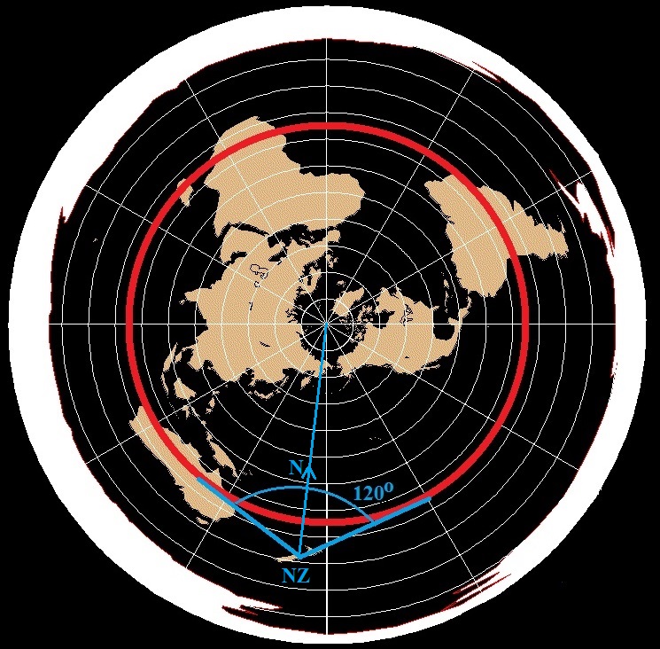
Here is the plan view of the Flat Earth on December 21st. The Sun is above the Tropic of Capricorn. Note that, as seen from New Zealand, the Sun will always be within 60 degrees of North, for a 120-degree span, just as is seen in the animation above.
The following animations show the comparison of globe and flat-earth models for both June 21 on the left (Summer in North, Winter in South)
and December 21 on the right (Winter in North, Summer in South), for latitudes in the north (top) to the equator (middle) and the south (bottom).
Click on any thumbnail to view it full size (800x400 px) in a new tab. Note how the upper-left chart (75oN, June 21) shows "Land of the Midnight Sun," where the globe model sun never sets. This
is actually the one of the 18 animations where the Flat Earth sun's path most closely resembles that of the globe model sun. Both Flat Earth and
Globe suns track left-to-right, above the horizon the whole time. On the right, the chart for (75oN, December 21) shows no daylight
at all ("Darkness at Noon"), whereas the Flat Earth sun never sets.
Note also how the lower-left chart (75oS, June 21) shows "Darkness at Noon," where the globe model sun never rises.
Here, the Flat Earth sun is above the horizon the whole time. On the right, the chart for (75oS, December 21) shows
"Midnight Sun", wherein the Flat Earth sun never sets, but stays close to North, unlike the Globe model sun, which travels from south
to west to north to east to south daily.
As you go down the array of animations, you'll notice that the divergences of Flat Earth model and Globe model suns are worse for some
situations than others. For example, the charts for (30oS, December 21) and (60oS, December 21) are both like
that for New Zealand, with the globe model sun setting in the southwest, while the Flat Earth model sun "sets" in the northwest.
| Latitude | JUNE 21 | DECEMBER 21 |
|---|---|---|
| 75oN | 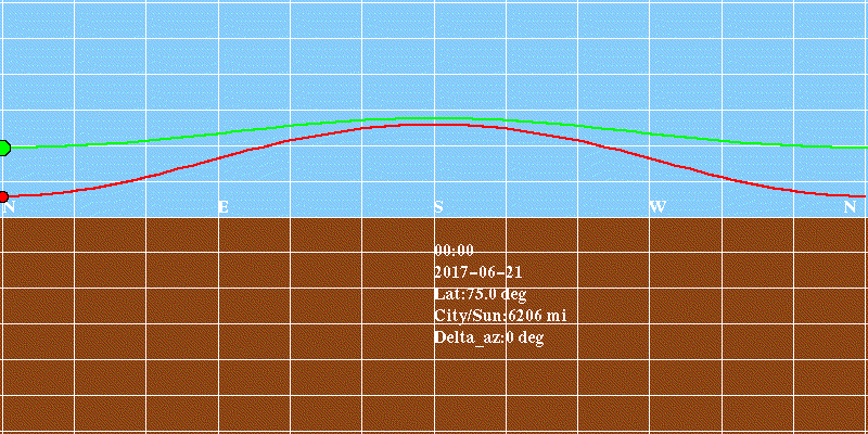 | 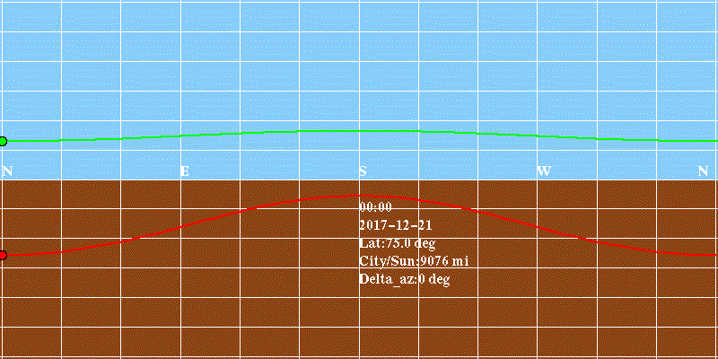 |
| 60oN | 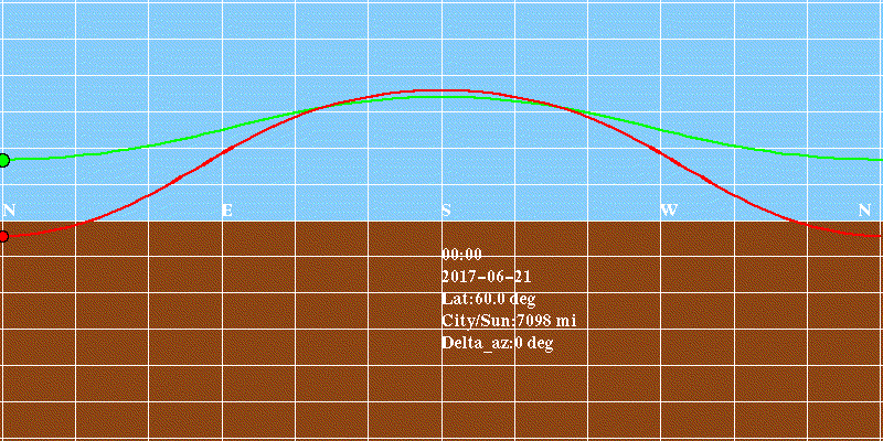 | 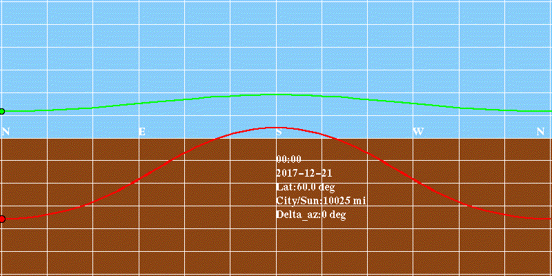 |
| 30oN | 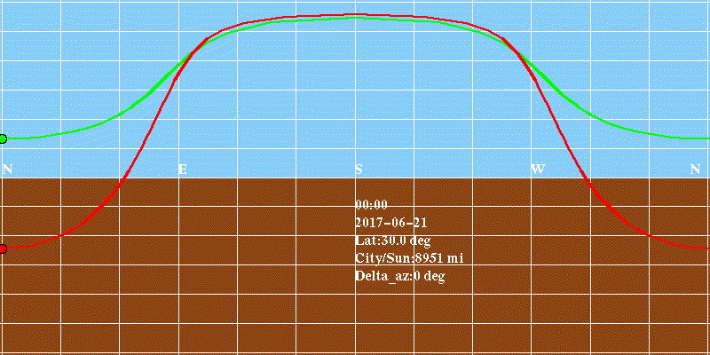 | 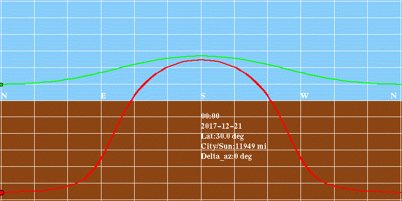 |
| 15oN | 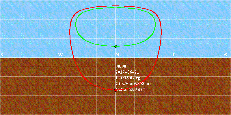 | 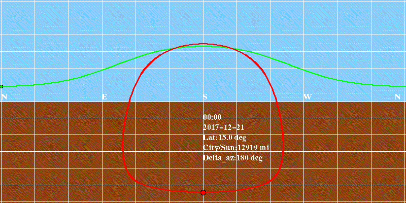 |
| EQ | 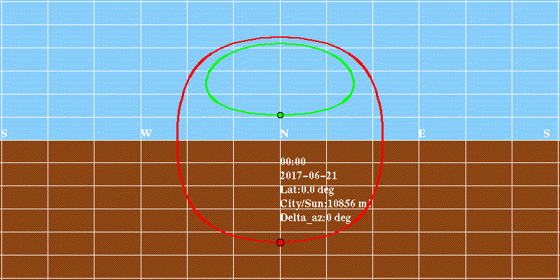 |  |
| 15oS |  | 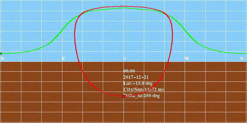 |
| 30oS | 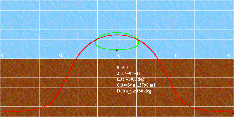 | 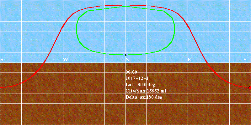 |
| 60oS | 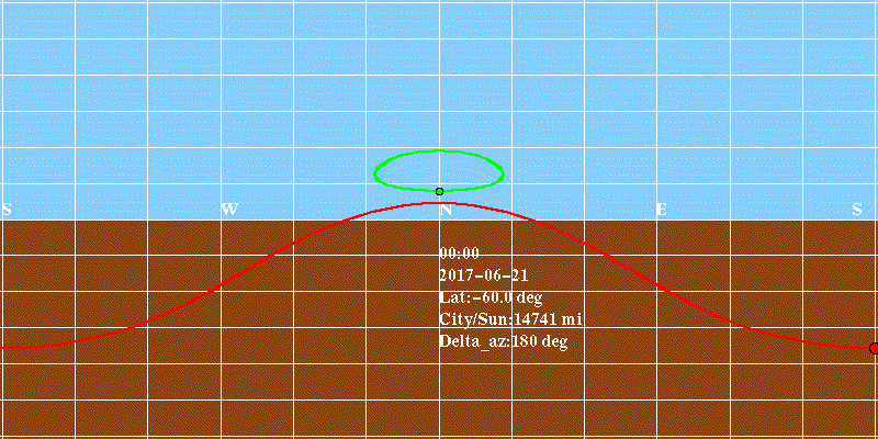 | 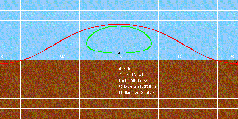 |
| 75oS | 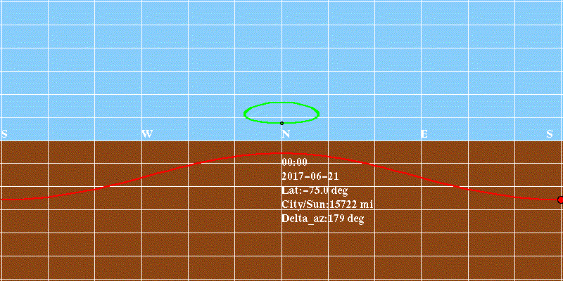 | 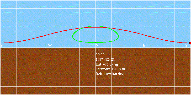 |
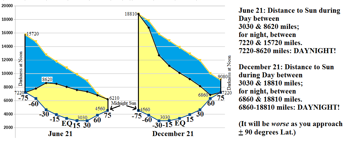
If you spend some time on the New Zealand animation above, you'll see that "nighttime" occurs when
the FE Sun is farther than 14,200 miles. Since the closest the FE sun gets is 3,283 miles, you could say that a FE Sun distance of
anywhere from 3,283 miles to 14,200 miles is "daylight", and FE sun distances greater than that (all the way to a maximum of 16,700
miles) correspond to "nighttime".
I've run my Python app for several latitudes, both summer and winter. The chart below shows the distances from the place of
observation to the Flat Earth Sun (considered to be 3000 miles above the flat earth, going over tropic of cancer in summer, and
tropic of capricorn in winter). The values along the lower trace of the plot are the minimum distances to the FE Sun, in miles.
(These represent the FE sun at its closest, at noon or so). The values along the top trace are just the maximum such distances.
The values along the middle are the Flat Earth sun distances for times corresponding to when the sun rises or sets,
defining the actual onset of day or night. For FE sun distances longer than these (e.g. anything over 14,200 miles in NZ on Dec. 21st),
one would expect that it would be dark, for the Flat Earth Model to be consistent.
Note that at 75N on June 21, and 75S on December 21, there is all daylight and no night ("Midnight Sun"). Likewise, it's all
night and no day ("Darkness at Noon") at 75N in winter and 75S in summer. For other latitudes/seasons, yellow indicates FE sun
distances corresponding to "daytime" as we know it (Globe Model), and blue indicates nightfall.
Here's the Rub: This disproves the main "Flat Earth" model, wherein the sun floats 3000 miles above the earth. Note that there are
points on the graph where anything farther than ~7000 miles is "night" (60N in winter for example). BUT, there are also points
where it can be daylight, and the FE sun is as far away as 18,000 miles!
This puts a huge kink in the claim that "The sun doesn't rise or set, it just shrinks to a point as it gets far away, and
vanishes".
How far away is the sun when it's too far away to see? 7,000 miles? 18,000 miles? Above 7000 miles, the blue and yellow areas
OVERLAP - it's a conundrum! For solar distances between 3030 and 6860 miles, the Flat Earth sun is close enough for it to be Daylight.
But, for distances above 6860 miles, all the way up to 18810 miles, the Flat Earth sun is sometimes too far to be seen,
but is close enough to be seen at other times! The Flat Earth model is inconsistent - its results are a Paradox.
Last Update: Dec. 6th, 2017
Try these other NMSR Pages on Flat Earth:
 December 12th, 2018 NMSR Meeting: Bruce Lacey, on "A Flat Earther's Journey and Perspective"